

 See the bike rental
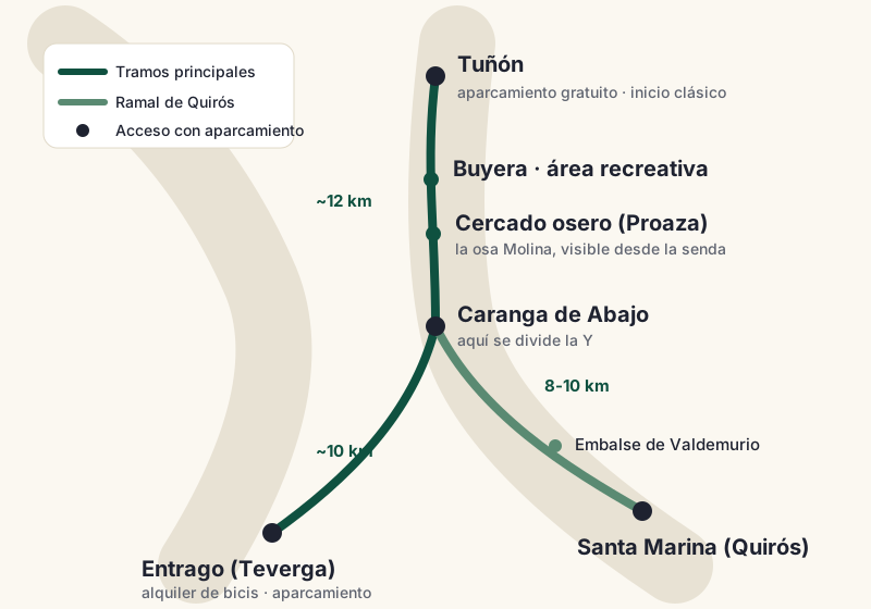
The Ruta del Oso is shaped like a Y: three sections adding up to about 30 km between Tuñón, Entrago and Santa Marina. This map shows them all, with their free car parks and their points of interest.
The map, in 30 seconds
If you are in a hurry, this is what you need to know. The trail starts in Tuñón, 25 minutes from Oviedo, and runs south to Caranga de Abajo, where it splits in two: one arm continues to Entrago (Teverga) and the other climbs to Santa Marina (Quirós).
The surface is smooth across the whole network, the gradient is barely noticeable except on the Quirós branch, and the tunnels are lit.
Three figures to get your bearings: from Tuñón to the bear enclosure at Proaza it is 10.5 km, from Tuñón to Entrago 21-22, and the whole network adds up to about 30 km, which becomes up to 60 if you ride everything out and back. That is enough to choose; the details are below.
The three sections on the map
Section 1 · Tuñón–Caranga (Santo Adriano valley, ~12 km)
It is the gateway coming from Oviedo and the section with the most buzz.
- Halfway along it passes the Buyera recreation area and the bear enclosure, level with Proaza.
- Genuinely flat: bikes with trailers and pushchairs manage here with ease.
Section 2 · Caranga–Entrago (Teverga valley, ~10 km)
The favourite for scenery hunters: stone tunnels dug for the mining railway and the gorge on the way to Teverga.
- Our recommendation if you can only do one full section and have already seen the enclosure.
Section 3 · Caranga–Santa Marina (Quirós valley, 8-10 km)
The quiet branch, with the Valdemurio reservoir as its star and far less bike traffic.
- It is the only one with a gradient you can feel: climbing towards Santa Marina you will appreciate an e-bike or fresh legs.
Download the map
In several spots along the valley the mobile signal comes and goes, especially between Caranga and Entrago. Save the map on your phone before leaving home and forget about it: download it here (it stays sharp at any size and weighs less than a photo).
We are also preparing a printable PDF version and a GPX track for GPS devices: as soon as they are ready, they will be downloadable from this very page.
Villages along the way
The trail crosses four municipalities and their villages are the natural stops of the route: Tuñón and Villanueva (Santo Adriano) at the northern entrance, Proaza at the heart of the route with the bear enclosure and the Bear House, Caranga de Abajo at the junction of the Y, Entrago and San Martín (Teverga) at the end of the main route, and Santa Marina with Bárzana (Quirós) on the reservoir branch.
The guides to each village, with where to eat and what to see, are in the villages section.
Car parks marked on the map
The three useful car parks are free:
Tuñón · ~40 spaces
Start the classic route towards the enclosure and Entrago.
- Free, next to the northern trailhead
- The first to fill up on public holidays
Proaza · ~20 spaces
Short plan with kids: the enclosure is a stroll away.
- Free, 200 m from the trail
- Bars and a fountain in the village
Entrago · ~60 spaces
Do the Teverga section or pick up your rental bike.
- Free, the largest of the three
- Bike rental point right next door
On long weekends and summer weekends, Tuñón fills up by mid-morning. If you arrive after 11, head straight for Entrago or Proaza and start from there.
The points of interest, north to south
- Buyera recreation area (Santo Adriano): picnic tables, a fountain and the access to the enclosure.
- Bear enclosure (Proaza): visible from the trail itself. Today it is home to Molina, a female bear rescued as a cub; until 2025 it was the home of the famous Paca and Tola.
- Peñas Juntas gorge (between Proaza and Caranga): the walls close in over the trail; the most photographed corner of the route.
- Tunnels of the Teverga section: carved into the rock and cool even in August.
- Valdemurio reservoir (Quirós): a sheet of water with a picnic area and a wooden walkway, ideal for the mid-route sandwich.
Which section to choose for your plan
Here it is, just as we tell anyone who asks at the rental point:
- With small children or short on time: Tuñón–Proaza and back, 21 km by bike or half of it on foot, with Molina the bear at the halfway point.
- First visit without kids: the full Tuñón–Entrago by bike, which sees it all.
- Looking for peace on an August Saturday: the Quirós branch, where the trail breathes.
- On foot: the Entrago–Proaza stretch rewards every step the most — the reasons are in the most beautiful section of the route.
For the exact distances of every combination, check how many kilometres the route has. And if you are doing it by bike, book your rental in advance: in high season the bikes sell out, and the prettiest map will not pedal for you.
More official information on the greenway at viasverdes.com and on the wider area at turismoasturias.es.
 Ruta del Oso